


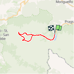
lac de braies - lac colli alti

XavierFaidix
User

Length
19.7 km

Max alt
2285 m

Uphill gradient
905 m
Km-Effort
32 km

Min alt
1496 m

Downhill gradient
907 m
Boucle
Yes
Creation date :
2019-07-14 06:42:41.183
Updated on :
2019-07-14 14:47:57.824
4h41
Difficulty : Medium

FREE GPS app for hiking
 SityTrail
IGN / Geographical institutes
SityTrail Plus
The world is yours!
About
Trail Walking of 19.7 km to be discovered at Trentino-Alto Adige/Südtirol, South Tyrol, Prags - Braies. This trail is proposed by XavierFaidix.
Positioning
Country:
Italy
Region :
Trentino-Alto Adige/Südtirol
Department/Province :
South Tyrol
Municipality :
Prags - Braies
Location:
Unknown
Start:(Dec)
Start:(UTM)
277086 ; 5175855 (33T) N.
Comments